
The Powerline-Morley Property is located approximately 2 km southeast of the town of Schreiber in northern Ontario, north of Lake Superior in the Thunder Bay Mining District.
The property comprises 11 single-cell mining claims totalling approximately 218 hectares. Our primary target metal is gold, with showings of zinc, silver, and potentially economic iron deposits occurring within quartz veins and alteration zones across diverse rock types.
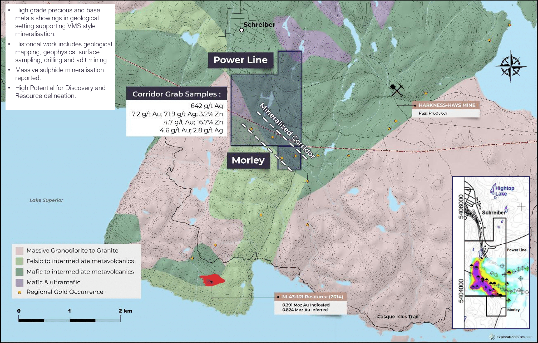
Three mineralised occurrences have been identified and supported by historic exploration.
The city of Thunder Bay (150 km from the property) is a regional exploration and services hub.
This predominantly sulphide facies iron formation occurrence is hosted within metavolcanic and metasedimentary rocks representing a fractured, brecciated, and contorted section of the main Morley iron formation, with mineralisation occurring within structurally controlled, high-stress zones often exhibiting alteration.
Detailed historic sampling has identified gold values in massive pyrite, gossan, laminated chert, and pyritic quartz veins with narrow zones of zinc.
Historic results include a 1956 drill program which intersected several mineralised zones.
Assays from the drilling included a 61 cm section assaying at 5.1 g/t Au and trace copper near the surface, while a 10 cm section at depth assayed 0.08% Cu, 16.69% Zn, and 2.07% Pb. In the northwest of the occurrence, anomalous gold values of 4.6 ppm Au and 2.8 ppm Ag over 7.16 m, including 1.22 m grading 18.6 ppm gold and 7.8 ppm silver.
This area represents an extremely well-preserved, pyrite and chert-rich sedimentary deposit situated within a late Archean metavolcanic suite.
Spectacular examples of banded, bedded, laminated, and nodular pyrite are present on the Morley Pyrite dump.
Historic reports indicate an average assay of the ore zone gave 27.48% S and 41.54% Fe. The average of three representative samples of massive sulphides graded 3.2% zinc, while ten similar samples of gossan material averaged 2.7% Zn.
Located near the centre of the property within felsic metavolcanics, this occurrence remains primarily an Ag, Cu, and Pb target.
Historical data indicates disseminated chalcopyrite mineralisation within a historic trench, as well as a 12-inch wide carbonate vein which assayed 708 ppm Ag and associated anomalous Au results.
Past producing gold mines in the area include the North Shore Gold Mine, located approximately 3 km south-southwest of the Powerline-Morley Property, which produced 3,808 tonnes at an estimated grade of 0.64 oz/t Au.
The smaller Harkness-Hays Mine was located approximately 3 km east-northeast of the property and produced 69.5 tonnes at an average grade of 2.9 oz/t Au.